|
|
||
|---|---|---|
| .. | ||
| pkg | ||
| ChangeLog | ||
| README.md | ||
| TODO | ||
| app-icon.js | ||
| app.js | ||
| gipy.png | ||
| interface.html | ||
| metadata.json | ||
| screenshot1.png | ||
| screenshot2.png | ||
| settings.js | ||
README.md
Gipy
Gipy allows you to follow gpx traces on your watch.

It is for now meant for bicycling and not hiking (it uses your movement to figure out your orientation and walking is too slow).
It is untested on Banglejs1. If you can try it, you would be welcome.
This software is not perfect but surprisingly useful.
Features
It provides the following features :
- display the path with current position from gps
- detects and buzzes if you leave the path
- buzzes before sharp turns
- buzzes before nodes with comments (for example when you need to turn in https://mapstogpx.com/)
- display instant / average speed
- display distance to next node
- display additional data from openstreetmap :
- water points
- toilets
- artwork
- bakeries
optionally it can also:
- try to turn off gps between crossroads to save battery
Usage
Preparing the file
You first need to have a trace file in gpx format. Usually I download from komoot or I export from google maps using mapstogpx.
Note that mapstogpx has a super nice feature in its advanced settings. You can turn on 'next turn info' and be warned by the watch when you need to turn.
Once you have your gpx file you need to convert it to gpc which is my custom file format. They are smaller than gpx and reduce the number of computations left to be done on the watch.
Just click the disk icon and select your gpx file. This will request additional information from openstreetmap. Your path will be displayed in svg.
Starting Gipy
Once you start gipy you will have a menu for selecting your trace (if more than one). Choose the one you want and here you go :
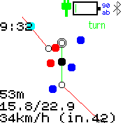
On your screen you can see :
- yourself (the big black dot)
- the path (the top of the screen is in front of you)
- if needed a projection of yourself on the path (small black dot)
- extremities of segments as white dots
- turning points as doubled white dots
- some text on the left (from top to bottom) :
- current time
- left distance till end of current segment
- distance from start of path / path length
- average speed / instant speed
- interest points from openstreetmap as color dots :
- red : bakery
- deep blue : water point
- cyan : toilets (often doubles as water point)
- green : artwork
- a turn indicator on the top right when you reach a turning point
- a gps indicator (blinking) on the top right if you lose gps signal
- a lost indicator on the top right if you stray too far away from path
- a black segment extending from you when you are lost, indicating the rough direction of where to go
Settings
Few settings for now (feel free to suggest me more) :
- keep gps alive : if turned off, will try to save battery by turning the gps off on long segments
- max speed : used to compute how long to turn the gps off
Caveats
It is good to use but you should know :
- the gps might take a long time to start initially (see the assisted gps update app).
- gps signal is noisy : there is therefore a small delay for instant speed. sometimes you may jump somewhere else.
- your gpx trace has been decimated and approximated : the REAL PATH might be A FEW METERS AWAY
- sometimes the watch will tell you that you are lost but you are in fact on the path.
- battery saving by turning off gps is not very well tested (disabled by default).
- buzzing does not always work: when there is a high load on the watch, the buzzes might just never happen :-(.
- buzzes are not strong enough to be always easily noticed.
- be careful when GOING DOWNHILL AT VERY HIGH SPEED. I already missed a few turning points and by the time I realized it, I had to go back uphill by quite a distance.
Creator
Feel free to give me feedback : is it useful for you ? what other features would you like ?