|
|
||
|---|---|---|
| .. | ||
| ChangeLog | ||
| README.md | ||
| app-icon.js | ||
| app.js | ||
| app.png | ||
| metadata.json | ||
| openwind.png | ||
| openwind_screenshot.png | ||
| settings.js | ||
README.md
OpenWind
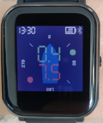
Receive and display data from a wireless OpenWind sailing wind instrument on the Bangle.
Usage
Upon startup, the app will attempt to automatically connect to the wind instrument. This typically only takes a few seconds.
Features
The app displays the apparent wind direction (via a green dot) and speed (green numbers, in knots) relative to the mounting direction of the wind vane. If "True wind" is enabled in settings and a GPS fix is available, the true wind speed and direction (relative to the mounting direction of the vane) is additionally displayed in red. In this mode, the speed over ground in knots is also shown at the bottom left of the screen.
Controls
In the main app, when true wind mode is enabled (see below), swiping left on the screen will temporarily disable GPS (to preserve battery); a small red satellite symbol will appear on the bottom right. Swiping right will turn GPS back on. The settings app provides the following two settings:
- True wind: enables or disables true wind calculations; enabling this will turn on GPS inside the app
- Mounting angle: mounting relative to the boat of the wind instrument (in degrees)